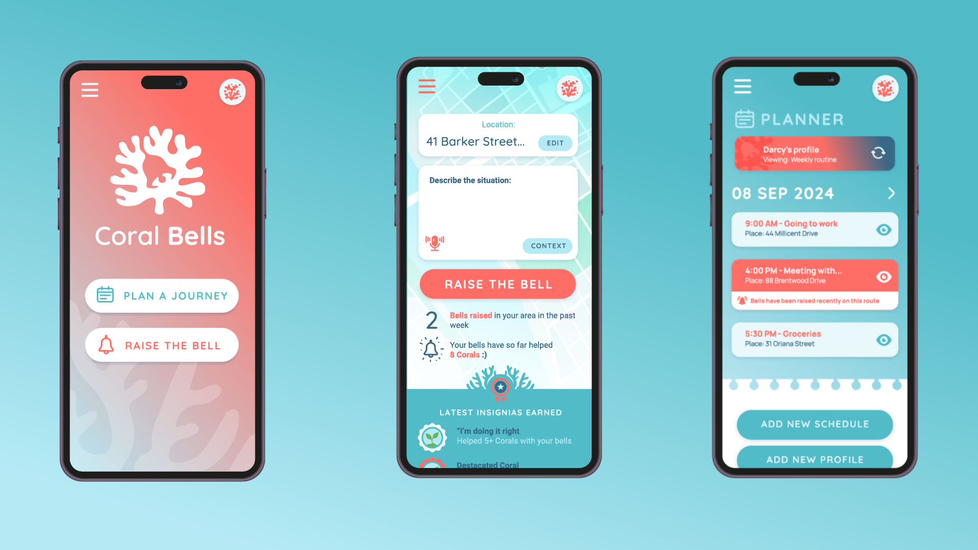
Back to Projects

Team Name:

The Late Bloomers


Team Members:


Evidence of Work

! Coral Bells !

Project Info

The Late Bloomers thumbnail

Team Name


The Late Bloomers


Team Members


Miris , Shann , Luz de Luna and 1 other member with an unpublished profile.

Project Description


Coral Bells

Guiding and Reassuring Safety, Holistically and Empathetically

A project of passion, tears, and 5AM deprivation, from 4 very busy people. A gift to our communities, and to everyone, as a thank you for this opportunity and your belief in us.


Access Our Demo!


Executive Summary


Our Project

Coral Bells is a welcoming mobile app designed to ensure that every journey is as safe and comfortable as possible. Whether it's a student heading home late, a parent sending their child off, someone with accessibility needs exploring new areas, or anyone feeling uneasy about travelling, Coral Bells offers tailored recommendations using a blend of open government data and crowd-sourced reports, known as “bells.” This combination provides users with personalised guidance based on their specific needs and circumstances.

Empowering Communities Through “Bells”

Inspired by the delicate yet resilient bell-shaped blooms of the “Coral Bells” flower, we view our users— our “corals”— as integral members of their communities. The “bells” represent safety alerts and underscore how each user's input enhances safety and comfort for everyone. Our aim is to see these corals blossom, empowering users to explore confidently and visit areas they might have previously avoided. By promoting personal security and safety, we support local tourism and regional development— encouraging safe exploration leads to confidence and the iniative to travel, or even just feeling more relaxed in everyday journeys.

Personalised Guidance and Community Contribution

The app allows users to describe their upcoming journey using natural language. It then combines this information with their profile, demographic, preferences, and a range of open government and crowd-sourced data to offer a friendly, tailored guide to their destination. For example, students walking alone at night will be recommended well-lit, populated areas; parents ensuring a safe route for their children will receive recommendations of nearby facilities; and people with disabilities will be given routes with improved accessibility.

The “raise the bell” feature encourages users to report safety incidents or concerns, with contributions recognised through in-app gratitude, badges, and notifications when a raised bell has benefited somebody. We seek to reinforce the importance of community involvement, by inspiring people to care for one another's safety and wellbeing.

Integrating Data for Comprehensive Safety Insights

By blending crowdsourced data with open government information, Coral Bells provides a comprehensive view of safety across various locations. This integration allows for personalised guidance and promotes civic engagement. For instance, the app uses traffic signal configurations and road crash data to guide users away from high-risk areas, while crocodile sightings statistics will help tourists be safe and confident when visiting regions such as the Northern Territory. This approach helps users make informed decisions and navigate their journeys with greater ease and security.

Advocating for Inclusive Data Access

Our long-term vision extends beyond immediate safety and comfort. We aim to inspire communities to support each other proactively and seamlessly. We are committed to improving access to data related to vulnerable and marginalised groups. Given this, we recommend that governments and organisations provide such data so we can identify and address previously-invisible concerns, creating meaningful impact within existing constraints. This will help us address the unique needs of these groups and enhance overall community wellbeing.

Holistic Insights Through Data Analysis

Coral Bells features a web-based dashboard that consolidates user reports and government data, offering valuable insights and key reports for policymakers and organisations. Powered by AI, this dashboard generates executive briefs and uncovers new trends, revealing connections between safety and community wellbeing. Our analysis promotes a deeper understanding of how safety concerns impact community health and vitality.

Empowering Communities and Improving Data

Ultimately, Coral Bells goes beyond traditional safety guidance, by thinking laterally and holistically— we want to foster a connected and empathetic community. Our app's design, features, and mission amplify the voices of under-represented groups, enhance personal security, and provide critical insights into community wellbeing. By prioritising safety and understanding, Coral Bells demonstrates that a thriving, informed society is built on care, mutual support, and collective commitment to improvement.

With safety and security being a pillar for everyone's wellbeing and confidence, we believe that by putting safety first, we can discover and solve a range of problems, including the boost in tourism and building of new and up-to-date data sets that benefit our communities and governments.


Our Team

We are The Late Bloomers, a team of people who complemented each other throughout the participation:

  • Luz de Luna Gomez Gonzalez
  • Emilian Roman
  • Shann Roberts
  • Tom Jia

Our Challenges and Goals

Enhancing Public Safety: The Bell of Safety

Our Goal: Improve public safety and reduce risks from various safety incidents.

GovHack Challenges: Crocodile Watch: Enhancing Public Safety; AI applications using Open Road Crash data

Solution:

  • Unified Safety Alerts (Bell of Safety):

    • “Raise the Bell”: Users can report various safety incidents such as crocodile sightings, car crashes, bush fires, and hazards, or simply express feelings of unease. This crowdsourced data, combined with existing open government data, informs the safety guidance we offer users and provides valuable insights, recommendations and crowd-sourced data to governments.
    • Safe Places Map: To avoid inadvertently guiding users through potentially dangerous areas, the map exclusively highlights “safe places” such as hospitals, police stations, and other emergency facilities. This precautionary approach ensures users are only directed to known safe locations, minimising unnecessary anxiety.
    • Natural Language Text: Information and alerts are delivered primarily through natural language text. This avoids suggesting alternative paths or highlighting hazards, ensuring users receive reassuring and useful guidance without inducing undue worry.

Inspiring Civic Engagement: Corals Contributing to Community

Our Goal: Increase civic participation and enhance community connection and resilience.

GovHack Challenges: Civic participation for a more resilient, cohesive democracy.

Solution:

  • Civic Contributions (Coral Voices):

    • Community Involvement: Users can actively participate by “raising the bell” to share safety incident reports or feelings of unease in a particular area. This feature empowers all users, including those from under-represented groups, ensuring their concerns and observations are heard and considered.
    • Transparent, Impactful Engagement: By engaging users from diverse backgrounds, we aim to inspire contributions that drive strategic and societal change. Empowering users helps to address invisible sources of discomfort and fosters a greater sense of community responsibility.
  • Building Communication and Understanding (Coral Feedback):

    • Government Communication: We provide insightful, relevant and up to date reports to local government services, and facilitate a platform for users to share their experiences, fostering a transparent, more engaged communication with policy makers.
    • Community Connection: We incorporate gratitude into our application—when someone's “raise of the bell” benefits another person, the former will receive a notification in the app, thanking them for their contribution and letting them know how their input helped.

Innovating Wellbeing Measurement: Insights from Safety Data

Challenge: Enhance the measurement and understanding of societal wellbeing using diverse data sources.

GovHack Challenges: Innovating Wellbeing Measurement – Uncovering New Connections

Solution:

  • Inferring Wellbeing from Safety Reports (Coral Insights):

    • Safety Data as a Wellbeing Indicator: The app provides valuable indirect insights into community wellbeing through its safety data. By analysing patterns in safety incidents and reported feelings of unease, we gauge aspects of community wellbeing. Frequent safety incidents or widespread unease may indicate underlying concerns, while fewer incidents and a sense of security suggest higher community wellbeing.
    • Data Integration: Combining user-generated safety reports with existing open government datasets helps identify correlations and trends reflecting broader wellbeing factors. This integrated approach enriches our understanding of how safety and wellbeing intersect.
    • Enhanced Dashboard: An enhanced wellbeing dashboard will visualise how safety incidents and feelings of unease contribute to overall community wellbeing, providing a holistic perspective on how safety concerns impact quality of life.
  • New Indicators and Proposals (Coral Metrics):

    • Innovative Indicators: As an iidea, we can leverage insights from safety reports and user feedback to propose new wellbeing indicators. These indicators will reflect the connections between safety incidents and other social factors, offering a more comprehensive measure of community health and happiness.

Indirect Benefits and Positive Consequences: Boosting Tourism in the Northern Territory

Our Goal: Broader impact, even indirectly, e.g. boost local tourism and regional development through enhanced safety and confidence.

GovHack Challenges: Boosting Tourism in the Northern Territory

Solution:

  • Empowering Safe Exploration (Coral Routes):

    • Encouraging Confidence: By providing users with reliable safety information and personalised guidance, we help them feel more secure and confident in exploring new areas, including the Northern Territory. This confidence can indirectly encourage more frequent and diverse travel to these regions.
    • Highlighting Safe Attractions: While Coral Bells primarily focuses on safety, by ensuring that users feel secure, we contribute to a more inviting atmosphere for tourism. This can lead to increased visitation and support local economies without directly targeting tourism.
  • Supporting Regional Development (Coral Insights):

    • Data-Driven Insights: By analysing data trends from user interactions and safety reports, we provide valuable insights that can support regional development strategies. Understanding areas of high safety concerns or low confidence can help in addressing specific needs and improving infrastructure to better support tourism and local growth.

AI Integration and Data Extrapolation

  • AI Utilisation:

    • End-User Interaction: AI is employed to provide a natural, conversational interface for users, enhancing their experience as they interact with the app. This includes using AI for natural language processing to deliver user-friendly, reassuring information and leveraging voice-driven commands for convenience and accessibility.
    • Data Analysis and Reporting: AI is also used to distill safety and community data into concise, actionable insights. This includes generating executive briefs and recommendations for policy-makers and organisations. AI helps in analysing trends and extrapolating data to provide comprehensive and/or key reports.
  • Goals:

    • Data Extrapolation and Reporting: Coral Bells aims to extrapolate and analyse data from both user-generated reports and open government sources. The goal is to provide detailed insights and key reports that support policy-makers, governments, and organisations in making informed, strategic decisions which improve the safety and wellbeing of our communities. By leveraging both real-time data and historical trends, the project contributes to more effective safety measures, civic engagement strategies, and wellbeing initiatives.

Our Data Story

We enhance user safety and comfort by integrating open government data with crowd-sourced safety reports, the latter known as “bells” within the metaphor we embrace. These bells are user-reported incidents or concerns. They help in tailoring safety information and recommendations for personalised journey planning amongst other people (“corals”) within the community.

GovHack Open Data

Near Real-Time Bushfire Boundaries

  • URL: Near Real-Time Bushfire Boundaries

  • Usage: This dataset helps users avoid areas affected by active bushfires. When a user reports a concern or encounter with bushfire-related hazards ("raises a bell"), the app cross-references this with real-time bushfire boundary data to provide timely rerouting suggestions and safety advice.

Find Disaster Recovery Services and Support

  • URL: Disaster Recovery Services

  • Usage: This dataset identifies available disaster recovery services and support. In the event a user raises a bell regarding a disaster situation, the app directs them to nearby recovery services, helping them find necessary assistance quickly.

Weather and Flood Warnings Bureau of Meteorology

  • URLs:

  • Usage: Provides trusted weather and flood warnings. If users raise a bell about weather concerns, the app integrates these reports with current weather data to offer guidance on avoiding severe conditions and adjusting travel plans accordingly.

Crocodile Survey Data 2021-2022

  • URL: Crocodile Survey Data

  • Usage: Informs users of crocodile activity. User-reported bells about crocodile sightings or safety concerns are matched with survey data to advise on avoiding areas with high crocodile activity.

Traffic Signal Configuration plus Traffic & Signal Volume – Vic Gov

Train Service Passenger Counts – Vic Gov

  • URL: Train Service Passenger Counts

  • Usage: Shows peak train passenger times. User-reported bells about crowded trains are combined with this data to suggest less crowded travel times or alternative transport options.

Victoria Road Crash Data

  • URL: Victoria Road Crash Data

  • Usage: Provides information on road crash hotspots. Bells about road safety concerns are matched with crash data to suggest safer routes and avoid high-risk areas.

Speed Signs & Zones – Vic Gov

  • URLs:

  • Usage: Informs users about speed limits and signage. Bells related to speed-related concerns help users find roads with appropriate speed limits and clear signage, ensuring safer journeys.

Externally Sourced Data

  • Emergency Services Agency – ACT Gov

    • URLs:
    • ACT Emergency Services
    • ACT ESA Current Incidents
    • Usage: Details critical emergencies and current incidents. Bells raised about emergencies help users receive updated evacuation information and safety recommendations based on real-time data.
  • Air Quality – ACT Gov

    • URL: Air Quality Monitoring Data
    • Usage: Provides information on air quality. Bells related to air quality concerns help users with health issues, such as asthma, determine if it is safe to engage in outdoor activities.
  • Cyclist Crashes – ACT Gov

    • URL: Cyclist Crashes Heat Map
    • Usage: Highlights areas with high cyclist crash rates. Bells about cycling safety help users find safer routes and times to cycle, reducing the risk of accidents.
  • Temporary Road & Footpath Closures – ACT Gov

    • URLs:
    • Road Closures
    • Footpath Closures
    • Usage: Provides details on road and footpath closures. Bells raised about disruptions help users find alternate routes and avoid construction or maintenance areas, ensuring a smoother travel experience.

Our System & Architecture

Please note that due to the competition's time limits and this system's complexity, we can only demonstrate a proof of concept/prototype -- the code in the repository reflects this. However, we are confident that our proposed architecture is a sound solution.

The user-facing mobile app and government-facing dashboards are both powered by a hybrid back-end.

diagram

  1. The "Core", in effect, holistically unifies everything and drives it all, to provide a seamless experience to our end-users.
  2. We use LLMs to take end-user input in natural text/voice, synthesise relevant journey guides in a friendly, empathetic way, and provide executive briefs, reports and suggestions to governments/policy-makers.
    1. Our core comunicates with the LLMs by supplying end-user journey input, their demographic and (anonymised) profile, and reports ("bells") we've gathered from locations relevant to their journey.
  3. We use relational databases for storing open government data sets, the anonymised profiles & demographics of our users, and the incidents they've reported when they "raised the bell".
    1. This allows us to achieve our endeavour of holistically connecting everything together to provide personalised, relevant and empathetic guides, along with insightful reports for governments/policymakers.
    2. Storing the crowd-sourced data in a consistent, normalised way allows for effective building and aggregation of datasets.
  4. Our mobile app and web dashboard connect to the back-end using APIs that permit the submission of end-user data and retrieval of relevant information from the back-end.

#mobile #community #safety #empathy #holistic #civic

Data Story


We enhance user safety and comfort by integrating open government data with crowd-sourced safety reports, the latter known as “bells” within the metaphor we embrace. These bells are user-reported incidents or concerns. They help in tailoring safety information and recommendations for personalised journey planning amongst other people (“corals”) within the community.

GovHack Open Data

Near Real-Time Bushfire Boundaries

  • URL: Near Real-Time Bushfire Boundaries

  • Usage: This dataset helps users avoid areas affected by active bushfires. When a user reports a concern or encounter with bushfire-related hazards ("raises a bell"), the app cross-references this with real-time bushfire boundary data to provide timely rerouting suggestions and safety advice.

Find Disaster Recovery Services and Support

  • URL: Disaster Recovery Services

  • Usage: This dataset identifies available disaster recovery services and support. In the event a user raises a bell regarding a disaster situation, the app directs them to nearby recovery services, helping them find necessary assistance quickly.

Weather and Flood Warnings Bureau of Meteorology

  • URLs:

  • Usage: Provides trusted weather and flood warnings. If users raise a bell about weather concerns, the app integrates these reports with current weather data to offer guidance on avoiding severe conditions and adjusting travel plans accordingly.

Crocodile Survey Data 2021-2022

  • URL: Crocodile Survey Data

  • Usage: Informs users of crocodile activity. User-reported bells about crocodile sightings or safety concerns are matched with survey data to advise on avoiding areas with high crocodile activity.

Traffic Signal Configuration plus Traffic & Signal Volume – Vic Gov

Train Service Passenger Counts – Vic Gov

  • URL: Train Service Passenger Counts

  • Usage: Shows peak train passenger times. User-reported bells about crowded trains are combined with this data to suggest less crowded travel times or alternative transport options.

Victoria Road Crash Data

  • URL: Victoria Road Crash Data

  • Usage: Provides information on road crash hotspots. Bells about road safety concerns are matched with crash data to suggest safer routes and avoid high-risk areas.

Speed Signs & Zones – Vic Gov

  • URLs:

  • Usage: Informs users about speed limits and signage. Bells related to speed-related concerns help users find roads with appropriate speed limits and clear signage, ensuring safer journeys.

Externally Sourced Data

  • Emergency Services Agency – ACT Gov

    • URLs:
    • ACT Emergency Services
    • ACT ESA Current Incidents
    • Usage: Details critical emergencies and current incidents. Bells raised about emergencies help users receive updated evacuation information and safety recommendations based on real-time data.
  • Air Quality – ACT Gov

    • URL: Air Quality Monitoring Data
    • Usage: Provides information on air quality. Bells related to air quality concerns help users with health issues, such as asthma, determine if it is safe to engage in outdoor activities.
  • Cyclist Crashes – ACT Gov

    • URL: Cyclist Crashes Heat Map
    • Usage: Highlights areas with high cyclist crash rates. Bells about cycling safety help users find safer routes and times to cycle, reducing the risk of accidents.
  • Temporary Road & Footpath Closures – ACT Gov

    • URLs:
    • Road Closures
    • Footpath Closures
    • Usage: Provides details on road and footpath closures. Bells raised about disruptions help users find alternate routes and avoid construction or maintenance areas, ensuring a smoother travel experience.

Evidence of Work

Video

Homepage

Project Image

Team DataSets

GovHack Open Data: Speed Zones

Description of Use Informs users about speed limits and signage. Bells related to speed-related concerns help users find roads with appropriate speed limits and clear signage, ensuring safer journeys.

Data Set

GovHack Open Data: Victoria Road Crash Data

Description of Use Provides information on road crash hotspots. Bells about road safety concerns are matched with crash data to suggest safer routes and avoid high-risk areas.

Data Set

GovHack Open Data: Train Service Passenger Counts

Description of Use Shows peak train passenger times. User-reported bells about crowded trains are combined with this data to suggest less crowded travel times or alternative transport options.

Data Set

GovHack Open Data: Traffic Signal Volume Data

Description of Use Assists users in avoiding peak traffic times and locations. Bells related to traffic issues or congestion are analysed with traffic signal and volume data to provide alternative routes and improve travel efficiency.

Data Set

GovHack Open Data: Traffic Volume

Description of Use Assists users in avoiding peak traffic times and locations. Bells related to traffic issues or congestion are analysed with traffic signal and volume data to provide alternative routes and improve travel efficiency.

Data Set

GovHack Open Data: Weather Alerts JSON

Description of Use Provides trusted weather and flood warnings. If users raise a bell about weather concerns, the app integrates these reports with current weather data to offer guidance on avoiding severe conditions and adjusting travel plans accordingly.

Data Set

GovHack Open Data: Weather Warnings

Description of Use Provides trusted weather and flood warnings. If users raise a bell about weather concerns, the app integrates these reports with current weather data to offer guidance on avoiding severe conditions and adjusting travel plans accordingly.

Data Set

Externally Sourced Data: Footpath Closures

Description of Use Provides details on road and footpath closures. Bells raised about disruptions help users find alternate routes and avoid construction or maintenance areas, ensuring a smoother travel experience.

Data Set

Externally Sourced Data: Road Closures

Description of Use Provides details on road and footpath closures. Bells raised about disruptions help users find alternate routes and avoid construction or maintenance areas, ensuring a smoother travel experience.

Data Set

Externally Sourced Data: Cyclist Crashes Heat Map

Description of Use Highlights areas with high cyclist crash rates. Bells about cycling safety help users find safer routes and times to cycle, reducing the risk of accidents. Temporary Road & Footpath Closures – ACT Gov

Data Set

Externally Sourced Data: Air Quality Monitoring Data

Description of Use Provides information on air quality. Bells related to air quality concerns help users with health issues, such as asthma, determine if it is safe to engage in outdoor activities.

Data Set

Externally Sourced Data: ACT ESA Current Incidents

Description of Use Details critical emergencies and current incidents. Bells raised about emergencies help users receive updated evacuation information and safety recommendations based on real-time data.

Data Set

Externally Sourced Data: ACT Emergency Services

Description of Use Details critical emergencies and current incidents. Bells raised about emergencies help users receive updated evacuation information and safety recommendations based on real-time data.

Data Set

GovHack Open Data: Speed Signs

Description of Use Informs users about speed limits and signage. Bells related to speed-related concerns help users find roads with appropriate speed limits and clear signage, ensuring safer journeys.

Data Set

GovHack Open Data: Traffic Signal Configuration Data Sheets

Description of Use Assists users in avoiding peak traffic times and locations. Bells related to traffic issues or congestion are analysed with traffic signal and volume data to provide alternative routes and improve travel efficiency.

Data Set

GovHack Open Data: Crocodile Survey Data

Description of Use Informs users of crocodile activity. User-reported bells about crocodile sightings or safety concerns are matched with survey data to advise on avoiding areas with high crocodile activity.

Data Set

GovHack Open Data: Flood Networks

Description of Use Provides trusted weather and flood warnings. If users raise a bell about weather concerns, the app integrates these reports with current weather data to offer guidance on avoiding severe conditions and adjusting travel plans accordingly.

Data Set

GovHack Open Data: Disaster Recovery Services

Description of Use This dataset identifies available disaster recovery services and support. In the event a user raises a bell regarding a disaster situation, the app directs them to nearby recovery services, helping them find necessary assistance quickly.

Data Set

GovHack Open Data: Near Real-Time Bushfire Boundaries

Description of Use This dataset helps users avoid areas affected by active bushfires. When a user reports a concern or encounter with bushfire-related hazards ("raises a bell"), the app cross-references this with real-time bushfire boundary data to provide timely rerouting suggestions and safety advice.

Data Set

Challenge Entries

Crocodile Watch: Enhancing Public Safety

How can crocodile monitoring data be leveraged to create solutions that improve public safety and reduce the risk of crocodile encounters in the Northern Territory?

#Crocodile management

Eligibility: Open to all participants, including students, professionals, startups, and data enthusiasts.

Go to Challenge | 19 teams have entered this challenge.

AI applications using Open Road Crash data

How might we leverage road crash statistics and multi-agent AI-based web applications to enhance road safety and inform policy making?

#Innovative solutions for Analysis, Risk Control and Presentation of Road Crash Statistics

Eligibility: Open to everyone. See the expected outcomes and the use of Crash Stats data listed above

Go to Challenge | 13 teams have entered this challenge.

Civic participation for a more resilient, cohesive democracy.

How can we help more people to understand their democracy, have an opportunity to participate in civic life, contribute to their community, and/or feel a sense of belonging and responsibility?

#Civic Participation

Eligibility: Open to everyone. Submissions should use at least one government data source.

Go to Challenge | 27 teams have entered this challenge.

Boosting Tourism in the Northern Territory

How can data be leveraged to create innovative solutions that boost tourism in the Northern Territory, attract more visitors, and/or enhance their cultural experience?

#Northern Territory Tourism

Eligibility: Open to all participants, including students, professionals, startups, and data enthusiasts.

Go to Challenge | 25 teams have entered this challenge.

Innovating Wellbeing Measurement – Uncovering New Connections

We want to explore different ways to link data and outcomes to domains and indicators under the <a href="https://www.act.gov.au/wellbeing/wellbeing-framework/domains-and-indicators"> ACT Government’s Wellbeing Framework.</a> Exploring external data sources can provide broader insights into the factors influencing our wellbeing, and improve its measurement.

#Exploring new ways to look at societal wellbeing

Eligibility: No restrictions. Participants can be from any jurisdiction and are encouraged to be creative and use any legal datasets in applying the wellbeing framework.

Go to Challenge | 17 teams have entered this challenge.