Project Description
Problem Statement
Studies have shown that urban planners face significant challenges in predicting and preparing for future community needs, leading to inefficiencies and insufficient infrastructure development.
Key issues include:
- Static Forecasting: Traditional forecasting methods rely on periodic data updates, failing to adjust dynamically to new information. This results in outdated simulations and inaccurate planning.
- Resource Inefficiencies: Misallocation of resources due to inaccurate forecasting of housing demand, traffic, and public service requirements.
- Inadequate Infrastructure: Limited insight into future growth results in delayed infrastructure projects like schools, hospitals, and transportation.
- Lack of Public Engagement: Citizens rarely have visibility into planning efforts or a direct way to request infrastructure improvements based on real insights into community needs.
- Disconnect Between Needs and Planning: Misalignment between real community needs and urban planning, preventing sustainable growth.
These issues hinder the ability to develop resilient, inclusive communities that can adapt to increasing population demands.
Project Description
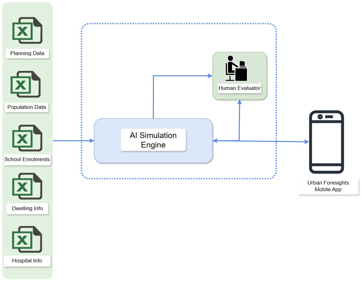
As a solution to the highlighted issues in urban planning, we propose to build an AI-Powered simulation engine that can communicate with the public and urban planners to assist in making informed decisions.
The AI engine processes and learns from a multitude of sources, building a model that simulates future planning scenarios. The system can predict potential shortages, resource gaps, and even flag possible future challenges. This ensures that urban planners can act proactively and sustainably by allocating resources and avoiding potential crises.
As shown in the figure, the system feeds in real-time data and can adapt to future community dynamics. By leveraging historical and real-time datasets, the tool uses machine learning models to predict key factors such as population density, housing demand, traffic patterns, and public services.
The AI-Driven Community Evolution Forecasting Tool is designed to empower both urban planners and citizens by providing real-time, data-driven insights into future community dynamics. Leveraging historical and real-time datasets, this tool uses machine learning models to predict key factors such as population density, housing demand, traffic patterns, and public services.
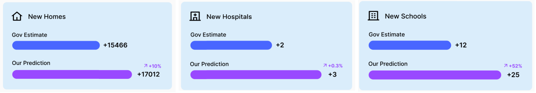
Planners can visualize the gaps between projected demands and existing or planned capacities through interactive graphs, helping them to prioritize resources for infrastructure projects. For instance, the tool can forecast a 30% increase in housing demand by a specific year and recommend expanding school or hospital capacities accordingly. Additionally, the tool highlights the impact of insufficient planning by illustrating how current infrastructure will fall short without timely interventions.
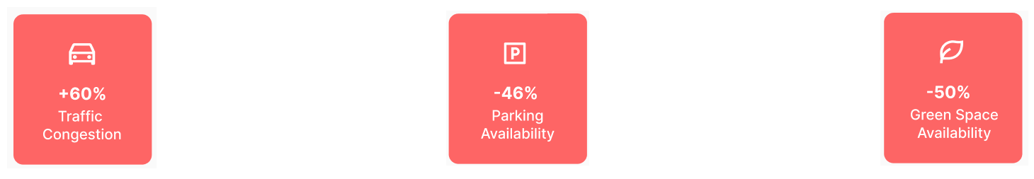
For citizens, the platform offers the ability to view these predictions and provide input by requesting or suggesting changes to the local infrastructure. They can request for additional parks, parking spaces, public facilities, or traffic management solutions based on the projections, ensuring their voices contribute to the development process.
The tool's dynamic nature ensures that predictions and visualizations are constantly updated as new data becomes available, offering the most accurate, up-to-date insights for both planners and the public.
As a future enhancement, we aim to augment the model's data understanding and processing capabilities. We believe that deriving insights from the following sources would enhance the system's decision-making strategy:
- Land Release Data: Information about newly released land parcels that become available for development.
- Land Sales/Registration Data: Records of transactions and registrations of land sales, indicating areas where new residential development might occur.
- Development Application Approvals: Data on approved applications for new construction projects, which indicates planned housing developments.
- Issuance of Occupation Certificates: Records of certificates issued upon the completion of construction, reflecting the actual availability of new residential units.
Mission
To create a collaborative, data-driven platform that empowers urban planners to make well-informed decisions for sustainable development and gives citizens a voice in shaping their community’s future. By integrating artificial intelligence with public data, our mission is to bridge the gap between community needs and urban planning, fostering transparency, engagement, and long-term sustainability.
Goal
Our goal is to deliver a robust, AI-powered forecasting tool that enhances urban planning through:
- Accurate, real-time predictions of housing, transportation, and public service needs.
- Interactive features for planners to ensure data-driven decision-making.
- A collaborative platform where citizens can actively request and suggest changes, promoting inclusivity in the planning process.
- Sustainable growth by aligning infrastructure development with actual and future community needs, reducing inefficiencies, and supporting long-term planning.
This solution aims to revolutionize how urban development decisions are made, ensuring that resources are allocated efficiently and that both planners and citizens are part of the decision-making process.
Data Story
Datasets
How we used the data:
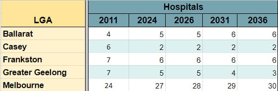
In order to make the analysis more precise we filtered our analysis to include only data from five LGA(Local Government Areas) in Victoria.
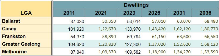
We started our analyzes using the VIF2023 LGA Population Household Dwelling Projections to 2036 dataset.
The dataset consists of population, dwellings and households information captured by the government census every five years. We utilized the population and dwelling information from the dataset to build forecasting models that can predict how the housing needs might change based on the variations in the population.
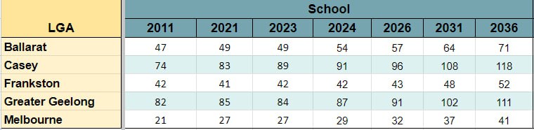
Later we augmented the data analysis by incorporating the number of schools and hospitals in the region. Our aim was to address the research questions:
1: How is the variation in population affecting the number of dwellings, number of schools and number of hospitals being planned and vice versa?
2. Is the current urban planning mechanism considering the correlation between these data sources?
3. Can an AI-model based simulation help in better planning?
By analyzing the information in the School Locations 2023 and Hospitals and Health Services Directory - External source datasets, we realized that the periods(every 5 years) at which the data is captured limits the systems ability to efficiently adapt to market dynamics.
We believe planning is an ongoing activity and a realtime system needs realtime data!
Hence, we propose an app that can connect, forecast and simulate data in real-time to make urban planning, a more efficient system.
VIF2023 projects future population size, distribution, and composition using historical data on population, dwellings, and households. The calculations are based on the Estimated Resident Population (ERP) as of 30 June 2022, with dwelling and household data derived from the ABS 2021 Census.
School Locations 2023 offers a comprehensive list of schools in Victoria, including their locations, LGAs, education sectors, and addresses.
The '2011 Local Government Area Profile' document details Victoria's LGAs, covering geographic area, population breakdowns, unemployment, healthcare, and education. All data is based on the year 2011.
The 'Hospitals and Health Services Directory' is the most up-to-date list of all hospitals in Victoria, reflecting data from 2024. This directory has been used to compile a comprehensive list of hospitals categorized by Local Government Areas (LGAs), providing an organized view of healthcare facilities across the state.